|
|
| Why is the readjustment important? |
The National Geodetic Survey (NGS) readjusted 67,693 GPS survey control points in the U.S. to the nationwide CORS network to:
- Resolve inconsistencies between each state's statewide HARN adjustments.
- Develop individual local and network accuracy estimates for each station in the network as required by the federal Geographic Data Committee (FGDC) Draft Geospatial Positioning Accuracy Standards (FGDC 1998).
| | What do components "NAD 83", "NSRS", and "2007" mean in the name NAD 83 (NSRS2007)"? |
NAD 83 (NSRS2007) is the readjustment of the North American Datum of 1983 (NAD 83) that was completed in 2007 that adjusted 67,693 GPS control points in the U.S. National Spatial Reference System (NSRS) to the Nationwide Contiously Operating Reference Stations (CORS) network.
North American Datum of 1983:
- Horizontal control datum (set of constants specifying the coordinate system used for calculating coordinates for points on the earth) for the United States, Canada, Mexico, and Central America
- Based on a geocentric origin and the Geodetic Reference System of 1980 (GRS 80) ellipsoid
- Based on 250,000 stations
- Implemented in 1986 to be compatible with modern surveying techniques
- National Spatial Reference System (NSRS): The consistent coordinate system managed and defined by NGS that defines latitude, longitude, height, scale, gravity, and orientation throughout the U.S. In addition, the NSRS comprises:
- Consistent, accurate, and up-to-date national shoreline
- Network of Continuously Operating Reference Stations (CORS), which supports 3dimentional positioning activities
- Network of permanently marked points
- Set of accurate models describing dynamic, geophysical processes that affect spatial measurements
2007: The year that the readjustment was completed.
| | What datums are involved in the readjustment? |
The adjustment involves two different datums: NAD 83 and the International Terrestrial Reference Frame (ITRF). The origin of both datums is at the mass center of the Earth, including oceans and the atmosphere, but the definition of each datum's origin is different.
| | What is the International Reference Frame (ITRF)? |
The International Reference Frame (ITRF) is a realization by a set of coordinates and velocities of reference points on the Earth. ITRF positions are generally determined with an accuracy of a few centimeters or better, even over continental or global distances. At this level of accuracy, tectonic plate motion (continental drift) and other forms of crustal motion must be taken into account. The use of ITRF positional coordinates is appropriate for those applications demanding the highest accuracy obtainable.
| | Were the NAVD 88 (North American Vertical Datum of 1988) elevations adjusted as part of NAD 83 (NSRS2007) adjustment? |
NO, the NAVD 88 elevation was not adjusted as part of the NAD 83 (NSRS2007) horizontal adjustment.
| | What is an ellipsoid height? |
An ellipsoid height is the vertical distance from a point to the reference ellipsoid along a line normal (perpendicular) to the ellipsoid.
| | Were the ellipsoid height of each mark involved in NAD 83 (NSRS2007) readjustment adjusted? |
Yes, the ellipsoid height of each mark involved in the readjustment was adjusted.
| | What is the horizontal positional shift in NC state Plane Coordinate System between: NAD 83/86, NAD 83/95, NAD 83/2001, and NAD 83(NSRS2007)? |
At station SMITHPORT (EZ5525) in Johnston County, the differences range from 0.004m to 0.330 m.
| |
|
Difference Northing (m) |
|---|
| Adjustment |
|
83/86 |
83/95 |
83/2001 |
83 (NSRS2007) |
|---|
| |
Northing (m) |
199,354.569 |
199,354.397 |
199,354.384 |
199,354.377 |
|---|
| 83/86 |
199,354.569 |
0.000 |
|
|
|
|---|
| 83/95 |
199,354.397 |
0.172 |
0.000 |
|
|
|---|
| 83/2001 |
199,354.384 |
0.185 |
0.013 |
0.000 |
|
|---|
| 83 (NSRS2007) |
199,354.377 |
0.192 |
0.020 |
0.007 |
0.00 |
|---|
| |
|
|
|---|
| Adjustment |
|
83/86 |
83/95 |
83/2001 |
83 (NSRS2007) |
|---|
| |
Easting (m) |
665,067.183 |
665,067.513 |
665,067.503 |
665,067.499 |
|---|
| 83/86 |
665,067.183 |
0.000 |
|
|
|
|---|
| 83/95 |
665,067.513 |
-0.330 |
0.000 |
|
|
|---|
| 83/2001 |
665,067.503 |
-0.320 |
0.010 |
0.000 |
|
|---|
| 83 (NSRS2007) |
665,067.499 |
-0.316 |
0.014 |
0.004 |
0.000 |
|---|
| |
|
|
|
|
|
|---|
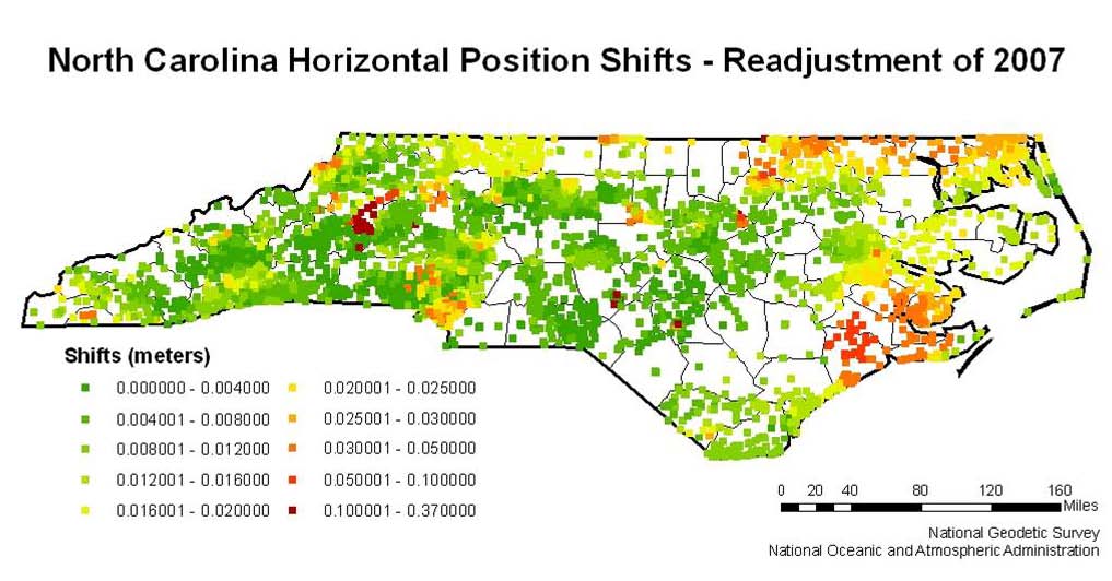
Note: The above table is an example for one (1) mark only. On a statewide scale, the differences between NAD 83/2001 and NAD (NSRS2007) can be seen on the following map:
| | How are the coordinates produced for the new adjustment? |
National Geodetic Survey (NGS) publishes coordinates in NAD (NSRS2007) and will later in both NAD 83(NSRS2007) and ITRF. NGS will use published transformation methods to transform each station's coordinates from the assumed stationary-based NAD83 datum to the dynamic, plate tectonic-based ITRF by adding velocity vector component to the coordinates. Therefore, even a station on the stable North American plate will have a velocity vector component in its ITRF set of coordinates, because the North American plate moves in the global reference frame.
| | What are the overall goals of the new readjustment? |
- Replace the current state-by-state HARN adjustment system, which produced a bewildering number of adjustment tags, with a nationwide adjustment system, so that all survey points in the NSRS will have the same adjustment tag.
- Remove any residual differences between NAD83 (CORS) positions that are produced by the NGS OPUS (Online Positioning User Service) utility and the various statewide HARN adjustments.
- Allow implementation of FGDC standards requiring each station to have individual estimates of local and network accuracies.
|
|
|
|
Contact Information
North Carolina Geodetic Survey
Main Office
200 Park Offices Dr
Durham, NC 27709
Phone: (919) 733-3836
Fax: (919) 733-4407
|
|
|